Bhutan - General Information
City at a Glance
|
Location |
150-km from Siliguri to Phyntsholing, Bhutan Border. |
|
Area |
46,500 sq. km |
|
Capital |
Thimphu |
|
Climate |
Summers : Max: 26° C, Min : 13° C. |
|
Population |
1,375,400 |
|
Languages |
Dzongkha, English, Nepali. |
|
Currency |
Ngultrum (India Rs 1 = Nu 1.00). |
|
Average Altitude |
7,554m |
|
STD Code |
975 |
|
Literacy Rate |
42.2% |
|
Best Time To Visit |
March to August |
|
Time |
30 minutes ahead of Indian Standard time. |
| Clothing | Summer : Heavy woolens , Winters: Heavy Woolens. |
History
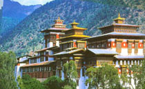
The name Bhutan is said to be derived from the ancient Indian term Bhotana, which means the end of the land of the Bhots (the Sanskrit name of Tibetans). The Bhutanese refer to their country as Druk Yul or land of the Peaceful dragon. Druk meaning dragon and extending from the predominant Drukpa School of Tibetan Buddhism. It was in the 8th century that Guru Rinpoche (the second Buddha) arrived in Bhutan from Tibet. He is the father of Nyingma Buddhism, which is currently practiced in Eastern Bhutan, and he is credited with bringing Buddhism to Bhutan. The name was given to a Tibetan monastery by a Tibetan lama (Tsangpa Gyare) after he heard the thunder dragons in the sky when he was searching for a place to build his monastery.
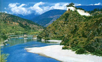
Geography
Bhutan is a landlocked country about 300km long and 150 km wide, encompassing 46,500 sq km. it is bounded on the north-west and north by Tibet. The rest of the country is surrounded by India, on the east is Arunachal Pradesh, on the south by Assam and West Bengaland on west by Sikkim. Virtually the entire country is mountainous and ranges in elevation from 100m to the 7541m Gangkhar Puensum peak on the Tibetan border. It can be divided into three major graphic regions, the high Himalaya of the north, the hills and valleys of the centre and the foothills and plains of the south.